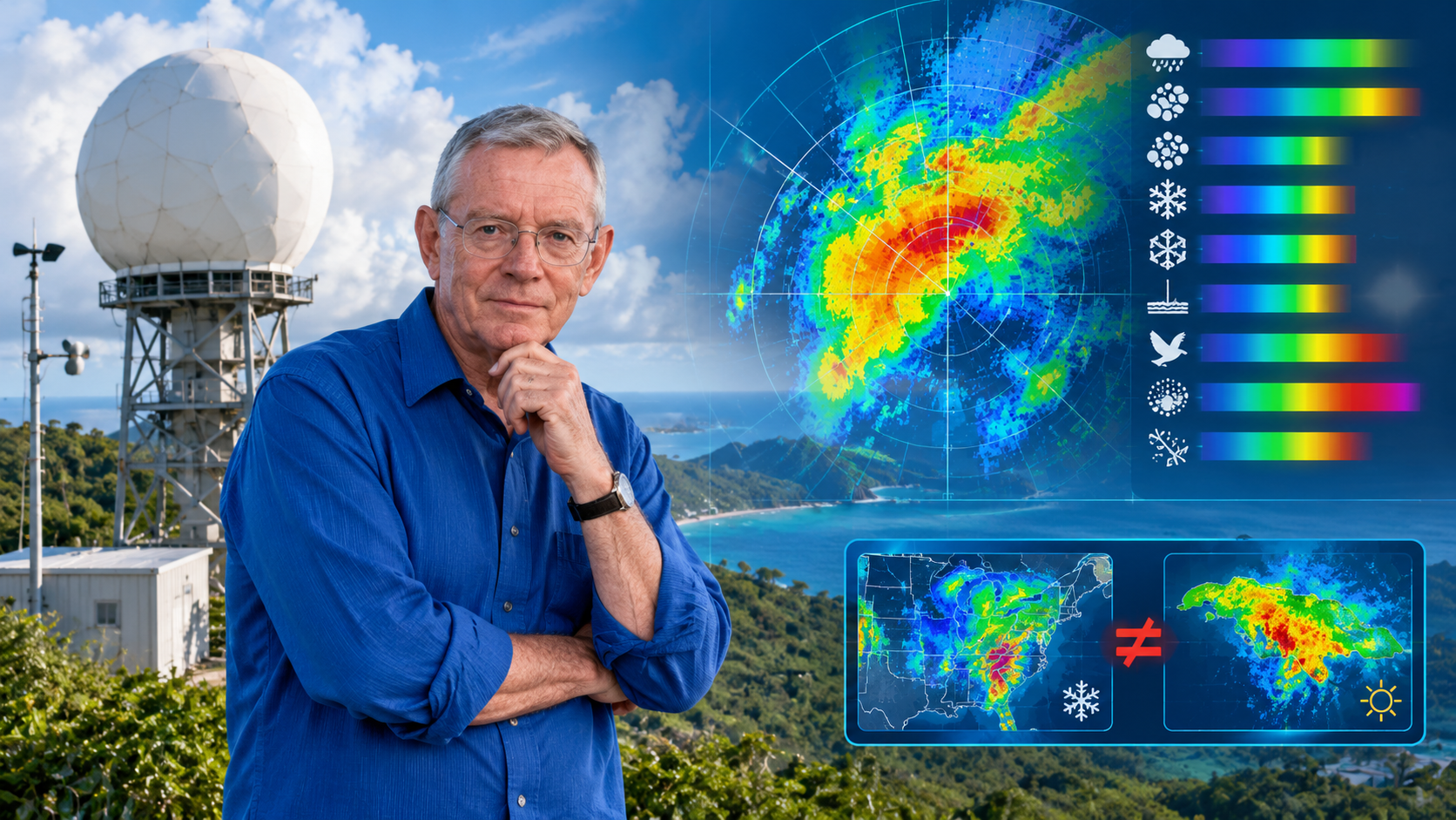
A post about hydrometeor classification in polarimetric radars, regional bias, and the invisible geography of algorithms. Versión en español aquí.
Hydrometeor classifiers (HCA/HID) operating in commercial polarimetric radars are, for the most part, fuzzy logic implementations built from observational campaigns, electromagnetic simulations, and microphysical knowledge generated in mid-latitudes. When these classifiers are deployed in tropical regions — such as the Caribbean or northern South America — their membership functions and decision thresholds no longer represent local physics. This article examines the case of two manufacturers (EEC and Vaisala), two countries (Jamaica and Colombia), and argues that the bias is not a calibration defect but a structural consequence of importing regional models disguised as universal products. A local validation framework is proposed and its application to microburst detection is explored.
1. Introduction: A Complaint That Wasn’t Technical
A colleague of mine at Colombia’s Civil Aviation Authority worked with data from a Doppler and Polarimetric radar. A few years ago we met, and she told me a complaint that wasn’t technical but almost existential: her radar’s hydrometeor classifier was flagging snow in warm regions of the country. Regions where the 0 °C isotherm sits at 4,800 meters and where it has never snowed at ground level. Pilots reported rain. The classifier insisted on snow.
She knew the radar was well calibrated. ZDR adjusted, PhiDP without offset, RhoHV coherent. And yet the flagship product — the one that tells you what kind of particle is falling from the sky — was lying.
That complaint is the origin of this article. Because the problem wasn’t a bug. It was something deeper and more uncomfortable: the classifier didn’t know Colombia. And the same could be said of Jamaica. Or Puerto Rico. Or any place where a polarimetric radar looks at a sky for which its algorithm was not designed.
2. Calibrating Is Not Classifying
It’s worth separating two things that are often confused.
Calibrating a polarimetric radar means ensuring that what it measures corresponds to what’s actually there. That Zh has no bias, that ZDR is centered, that PhiDP has no offset, that RhoHV reflects real coherence. It’s an instrumentation problem. Difficult, but bounded.
Classifying hydrometeors is something else. It means taking those already-calibrated variables and deciding, through a model, whether what you’re seeing is light rain, heavy rain, big drops, hail, graupel, dry snow, wet snow, ice crystals, biota, or clutter. It’s an inference problem.
The most common classifier in operational radars — in both EEC and Vaisala, as we’ll see — uses fuzzy logic. Membership functions are defined for each polarimetric variable, inference rules are built along the lines of «if Zh is high and ZDR is low and RhoHV is high, then probably hail,» and they’re combined to obtain a degree of membership for each class.
The problem is that those functions and those rules don’t come out of thin air. They’re built, adjusted, and validated with observational campaigns, electromagnetic simulations, and in-situ measurements made in a specific place. And there’s the catch: that «specific place» is almost never the tropics.
3. Two Cousins: EEC and Vaisala
This is where the story gets interesting. Because one might think the problem belongs to a single manufacturer. It doesn’t. It belongs to a shared philosophy.
3.1 EEC and the NOAA/NSSL Lineage
Jamaica operates an EEC Defender, S-band, 8.5-meter antenna. EEC — Enterprise Electronics Corporation — is headquartered in Enterprise, Alabama. It’s not poetic coincidence: it’s literal. The radar watching the Caribbean from Jamaica was manufactured in a city in the southern United States.
Everything indicates that EEC incorporated into its radars the classification line developed by the group of Alexander V. Ryzhkov and Dusan S. Zrnić at NOAA/NSSL, based on fuzzy logic. EEC’s own technical material points to their integration of the hydrometeor classification algorithms developed for the WSR-88D platform — the U.S. NEXRAD network — (Ryzhkov & Zrnić, 2019).
That classifier primarily uses:
- Zh (horizontal reflectivity)
- ZDR (differential reflectivity)
- RhoHV (correlation coefficient)
- KDP (specific differential phase)
- Temperature information
- Melting layer detection
And it classifies roughly ten categories: rain, heavy rain, big drops, small hail, large hail, graupel, dry snow, wet snow, ice crystals, and biological/non-meteorological echoes.
The membership functions of that classifier were built from polarimetric observation campaigns in Oklahoma, Alabama, and other mid-latitude continental regions; T-Matrix electromagnetic simulations; in-situ measurements; and expert microphysical knowledge. That is: rigorous physics, but physics of mid-latitude continents.
3.2 Vaisala and HydroClass
Colombia operates Vaisala radars, mainly WRM200 in C-band. Vaisala incorporates a module called HydroClass™, and explicitly states that it uses «a proven fuzzy logic algorithm» to classify meteorological and non-meteorological targets (Vaisala, 2021).
The classes it identifies are:
- Rain
- Hail
- Graupel
- Snow
- Wet snow
- Non-meteorological targets (insects, birds, sea clutter, wind turbines, military chaff, interference)
And the variables feeding the classifier are:
- ZDR
- RhoHV
- PhiDP
- KDP
- LDR (when operating in that mode)
3.3 The Key Point: A Shared Philosophy
Notice something. Neither of them trains with massive historical datasets. Neither uses modern machine learning. Both follow the same recipe:
- Physical simulation of hydrometeors (T-Matrix)
- Construction of characteristic regions in polarimetric space
- Classification via fuzzy logic
- Correction using ambient temperature
They’re cousins. They share physics, share method, share limitations. And they share the same problem when they land in the tropics: neither was built with the 0 °C isotherm at 5 km in mind.
That means the bias doesn’t come from «bad training data.» It comes from something deeper: the campaigns, the measurements, and the expert knowledge are from one place. The T-Matrix simulates particles, but the particles it simulates are the ones someone decided to simulate. The campaigns were done in Oklahoma, in Darwin, in Helsinki. The expert knowledge is expert in something.
The classifier isn’t «poorly trained.» It’s trained for another place. And that’s harder to fix than retraining with data.
4. Tropical Physics Is Not Mid-Latitude Physics
There’s an important nuance here that my reader should keep in mind: the symptom changes depending on the radar’s operating band, but the disease is the same.
4.1 The Case of Jamaica (S-band)
S-band has a huge advantage: rain attenuation is much lower than in C- or X-band. That means the problem isn’t attenuation. The problem is something else.
The 0 °C isotherm sits at 5 km. In mid-latitudes it sits at 2–3 km. A Jamaican radar can be sampling ice at 4 km altitude — ice that melts before reaching the ground. The classifier sees ice and says «snow.» The pilot reports rain. Both are right; the HID doesn’t distinguish between «there’s ice in the sampling volume» and «snow is falling at the surface.»
Warm microphysics dominates. Zipser et al. (2006) documented why maritime tropical convection — such as the Caribbean’s — exhibits warm microphysics signatures: efficient coalescence, high liquid water content, small-to-medium drops that rarely reach the freezing point at low levels. Unlike mid-latitude continental storms, where updrafts generate large ice structures, here rain is produced without the need for an extensive ice phase.
This translates into moderate reflectivities with high KDP. And the traditional boundaries of the classifier fail: they associate those reflectivity levels with ice mixtures, when in reality it’s efficient warm rain.
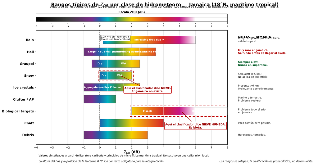
Figure 1. Typical ZDR ranges by hydrometeor class for Jamaica (18°N, maritime tropical). Adapted from Fabry’s (2015) scheme. Each horizontal bar represents the ZDR range associated with a category, colored according to a continuous chromatic scale. The ranges deliberately overlap to reflect the inherent ambiguity of polarimetric classification; class assignment is probabilistic, not deterministic. Note the absence of an operational «dry snow» region at the surface — the Snow bar corresponds exclusively to ice aloft that melts before reaching the ground — and the unusually wide Rain range, a consequence of tropical warm microphysics. The two dotted boxes highlight the most frequent confusions of the imported classifier: the Snow category, which in Jamaica corresponds to graupel aloft and not surface snow, and the Biological targets category, which the HCA erroneously labels as «wet snow» when in reality it’s biota. The dashed vertical line at ZDR = 0 marks the boundary between spherical and oblate particles, not a temperature; the 0 °C isotherm, which in Jamaica sits around 5 km altitude, must be consulted separately via soundings or vertical profiles.
The ambiguity between big drops and melting hail. In S-band the Mie effect is smaller than in C-band, but it doesn’t disappear. Large drops and melting hail can occupy neighboring regions of polarimetric space. The NSSL/Ryzhkov classifier, tuned with continental microphysics, tends to lean toward ice.
Biota is a year-round problem. Warm marine boundary layer, insects, birds. High ZDR with low RhoHV. The classifier says «wet snow.» It’s not snow: it’s life.
4.2 The Case of Colombia (C-band)
Here another problem is added: severe differential attenuation.
In C-band, intense tropical storms absorb and scatter energy asymmetrically between the H and V channels. If a rigorous correction based on KDP is not applied, Zh and ZDR drop artificially behind the convective core. And there the classifier goes haywire: it labels heavy rain as dry snow, melting hail, or total attenuation (Bringi & Chandrasekar, 2001; Vaisala, 2021).
4.3 The Lesson
Same classifier, same assumptions, same bias. But:
- In Jamaica (S-band), the problem is the high isotherm and warm microphysics.
- In Colombia (C-band), differential attenuation is added.
Same disease, different symptoms.
5. The Colombian Case: Two Manufacturers, One Challenge
Colombia offers a particularly rich case study, because at least two manufacturers with different classification philosophies coexist in its territory, both operating in C-band and both in a tropical regime.
5.1 SIATA (Medellín): EEC in C-band, Locally Adapted
The Early Warning System of Medellín and the Aburrá Valley operates a polarimetric EEC radar in C-band — the same manufacturer that supplies Jamaica’s radar — in complex topography and tropical Andean convection. This means it faces two simultaneous problems: tropical warm microphysics (high isotherm, large drops, graupel aloft) and the severe differential attenuation characteristic of C-band.
The SIATA team has developed local classification models by adapting traditional fuzzy logic, with KDP-based attenuation correction before feeding the membership vector (SIATA, 2020; Hoyos et al., 2016). Validation combines the dense Parsivel disdrometer network with lightning detection sensors and profiling radars.
The SIATA case is valuable for two reasons. First, because it demonstrates that it can be done well in tropical C-band, with the right instruments. Second, because it’s the same manufacturer as Jamaica, allowing a direct comparison: both are EEC, both use NSSL-HCA derivatives, but SIATA has been locally adapted while there is no public evidence that Jamaica has done the same.
5.2 Aerocivil (Colombia): Vaisala in C-band
Colombia’s Civil Aviation Authority operates Vaisala WRM200 radars in C-band. This is the case that originated this article: Vaisala’s HydroClass classifier reporting snow in warm regions where pilots report rain. A Finnish classifier, applied to a Colombian sky.
5.3 The Question That Arises on Its Own
If SIATA (EEC, C-band) has been locally adapted and Aerocivil (Vaisala, C-band) reports the classic symptom of regional bias, then the question isn’t «which manufacturer is better?» The question is: how many radars in the tropics are operating with classifiers that were never locally validated?
6. It’s Not an Anecdote. It’s a Documented Pattern
What my colleague saw in Colombia isn’t a rarity. It’s documented throughout the region and beyond.
Puerto Rico (NEXRAD TJUA, S-band). Research from the University of Puerto Rico at Mayagüez and collaborators has analyzed the response of the official NOAA HCA during hurricanes and tropical cyclones. Key finding: in pure tropical systems dominated by warm microphysics, the classifier erroneously labels torrential rain zones with moderate Zh and high KDP as «rain and hail mixture.» Adjustments have been proposed to raise ZDR and KDP thresholds in detecting very heavy rain.
Guadeloupe and Martinique (Météo-France, C-band). Cross-validation campaigns with TRMM and GPM have allowed calibration of the melting layer height — 4.5 to 5.0 km in the Caribbean — and adjustment of membership functions to avoid false «wet snow» classification at mid-levels.
Colombia (SIATA, C-band). The case already described. Local classification models adapting fuzzy logic, with multi-instrument validation (SIATA, 2020; Hoyos et al., 2016).
Colombia (Universidad Distrital, C-band). The book by Camargo-Camargo, Cadena-Contreras & Alejo-Zabala (2022) documents how factory-default models in commercial radars, designed for mid-latitudes, overestimate the presence of ice and make errors in the melting zone. Señalin’s (2021) thesis develops a classification model specifically adapted to the warm microphysical dynamics of low latitudes.
India (CAIPEEX / IITM). The CAIPEEX campaign of the Indian Institute of Tropical Meteorology used dual-polarization radars in X- and C-band combined with Parsivel and 2DVD optical disdrometer networks, plus airborne instrumentation. They evaluated fuzzy logic membership functions adjusted to monsoon drop size distribution versus the standard S-band matrices set for mid-latitudes.
Australia (Darwin, C-POL). Thompson et al. developed a 10-category HCA in C-band optimized for tropical environments. Their explicit motivation was the electromagnetic ambiguity between big drops/melting hail and wet snow caused by Mie effects in C-band — exactly the kind of confusion a mid-latitude classifier doesn’t resolve.
The pattern is clear: everywhere an imported classifier has been validated in the tropics, the same bias has been found. It’s not a problem of a poorly calibrated radar. It’s a structural problem.
7. How to Do It Right: The Recipe
If the problem is structural, so is the solution. It’s not about throwing away the classifier. It’s about domesticating it.
7.1 Multi-Instrument In-Situ Validation
The most robust scheme, pioneered by SIATA in Colombia, combines three components:
- Polarimetric radar: continuous spatial coverage, key variables (Zh, ZDR, RhoHV, PhiDP).
- Optical disdrometer network (Parsivel, 2DVD): directly measures drop size distribution (DSD) and fall velocity at the surface. Validates the radar’s microphysical assumptions.
- Altitude soundings: determine the atmosphere’s thermal structure and the height of the 0 °C isotherm. Crucial data for constraining classification models.
7.2 Attenuation Correction with KDP
In C- and X-band, differential attenuation correction based on KDP is mandatory before feeding the classifier’s membership vector. Without it, false classifications downstream of the convective core are inevitable. This applies both to Colombia’s Vaisala WRM200 radars and to SIATA in Medellín, both in C-band.
7.3 Re-Adjusting Membership Functions with Local DSD
Work by UNAM in Yucatán, Universidad Distrital in Colombia, and CAIPEEX in India all agree: the HCA’s beta membership functions must be built with electromagnetic scattering data (T-Matrix) fed with local DSDs. Not with the standard NEXRAD or European matrices.
7.4 Introducing Temperature and Height as Context Variables
The classifier should know at what altitude it’s measuring. A pixel at 5 km in Jamaica is not the same as a pixel at 5 km in Finland. If the HID doesn’t incorporate the height of the 0 °C isotherm, it’s doomed to be wrong.
7.5 Cross-Validation with Spaceborne Remote Sensors
Cross-referencing the 3D classification from the ground radar with the GPM DPR or TRMM PR classification allows confirmation of the vertical structure of the melting layer and graupel cores over sea and land in the tropics (Dolan & Rutledge, 2009, 2011).
7.6 Transparency and Quality Flags
A good operational HID should indicate uncertainty per class, include an «unknown class» or «low confidence» label, avoid forcing a classification when variables aren’t conclusive, and document which region it was trained for and what its limitations are.
8. Beyond the HID: The Microburst Opportunity
And this is where the article stops being a critique and becomes a proposal.
Because the hydrometeor classifier is not the final product. It’s an input. And for certain applications — microburst detection, severe convection nowcasting, early warning — the traditional HID falls short, not because it’s wrong, but because it wasn’t designed for that.
For microburst detection, the real value lies in combining:
- Predominant hydrometeor (HID output)
- ZDR column (updraft signature with big drops)
- KDP column (liquid water content)
- Doppler divergence (surface wind signature)
- Maximum reflectivity descent (downburst signature)
- Height of the graupel and hail region (charging mechanism)
- Thermodynamic profile (stability, CAPE, condensation level)
Traditional HIDs aren’t designed for this. They’re designed to say «this is rain» or «this is hail.» But a modern microburst nowcasting system could use HID outputs as one more variable within a broader scheme.
There’s a concrete opportunity here. With an S-band polarimetric radar like Jamaica’s — 8.5 m antenna, narrow beam, good resolution — one can develop a microburst risk classifier that:
- Uses the HID (or HydroClass, or NSSL-HCA) as an input, not as a final product.
- Incorporates ZDR and KDP columns as updraft detectors.
- Combines with low-level Doppler divergence.
- Constrains with local thermodynamic profile (0 °C isotherm at 5 km, CAPE, etc.).
- Validates with surface reports and the LLWAS network if one exists.
That would be more modern than traditional HCAs. And it would be a real contribution, not just a complaint.
9. Conclusions
Calibrating (instrumentally) ZDR and PhiDP is essential. But it’s not enough. The HID is a regional model disguised as a universal product. And in tropical, Andean, or simply different regions, that disguise falls apart.
My colleague’s anecdote at Aerocivil isn’t a rarity. It’s a symptom. It’s what happens when we import technology without importing context. When we believe that an algorithm trained in Helsinki or Enterprise, Alabama, can tell us what’s falling from the sky over the Magdalena Medio. Let my reader not believe that a radar manufacturer can develop costly field experiments in the country where it’s going to install the radar. They take results published by universities and research centers that do these studies … valid only for the places where those studies are done.
The solution isn’t to throw away the classifier. It’s to domesticate it: validate it with disdrometers, re-adjust its membership functions with local DSDs, introduce temperature and beam height as context, correct attenuation with KDP, and above all, know when not to believe it.
And then take the next step: use the HID for what it is — an input — and build on top of it systems that answer more useful questions: Is there going to be a microburst? Is it going to hail? Is it going to rain hard enough to flood the valley?
Because in the end, the HID isn’t a truth. It’s a trained opinion. And like any opinion, you need to know where it comes from.
References
Bringi, V. N., & Chandrasekar, V. (2001). Polarimetric Doppler Weather Radar: Principles and Applications. Cambridge University Press.
Camargo-Camargo, J. E., Cadena-Contreras, L. A., & Alejo-Zabala, G. (2022). Estudio de hidrometeoros basado en información de variables polarimétricas de radares meteorológicos para Colombia. Editorial Universidad Distrital Francisco José de Caldas.
Dolan, B., & Rutledge, S. A. (2009). A theory-based hydrometeor identification algorithm for X-band polarimetric radars. Journal of Atmospheric and Oceanic Technology, 26(10), 2071–2088.
Dolan, B., & Rutledge, S. A. (2011). A theory-based hydrometeor identification algorithm for X-band polarimetric radars. Journal of Atmospheric and Oceanic Technology, 28(5), 621–637.
Doviak, R. J., & Zrnić, D. S. (1993). Doppler Radar and Weather Observations (2nd ed.). Academic Press.
Hoyos, C. D., Ceballos, L. I., Pérez, J. S., & Sepúlveda, J. I. (2016). The hydrometeorological monitoring network of the Aburrá Valley (SIATA): An integrated approach for early warning systems. Proceedings of the American Meteorological Society.
Michaelides, S. (Ed.). (2019). Precipitation Science: Measurement, Remote Sensing, Research and Applications. Elsevier.
Ryzhkov, A. V., & Zrnić, D. S. (2019). Radar Polarimetry for Weather Observations. Springer.
Señalin, M. A. (2021). Modelo de clasificación de hidrometeoros para zonas ecuatoriales. Repositorio de la Biblioteca Digital de Bogotá.
SIATA. (2020). Radares meteorológicos: Equipamiento, procesamiento de señales y variables polarimétricas. Documentación técnica del proyecto, Área Metropolitana del Valle de Aburrá.
Thompson, E. J., Rutledge, S. A., Dolan, B., Chandrasekar, V., & Cheong, B. L. (2014). A dual-polarization radar hydrometeor identification algorithm for X-band. Journal of Atmospheric and Oceanic Technology, 31(12), 2611–2627.
Thompson, E. J., et al. A Robust C-Band Hydrometeor Identification Algorithm and Its Application to Long-Term C-POL Observations in Darwin, Australia. Journal of Applied Meteorology and Climatology.
Vaisala. (2021). Corrección de atenuación de radares meteorológicos banda-C. Nota de aplicación técnica, Vaisala Oyj.
Zipser, E. J., Cecil, D. J., Liu, C., Nesbitt, S. W., & Yorty, D. P. (2006). Where are the most intense thunderstorms on Earth? Bulletin of the American Meteorological Society, 87(8), 1057–1072.
Author’s Note
This article is a divulgative review based on published literature, manufacturer technical documentation, and field observations in Colombia and the Caribbean. Statements about EEC’s classifier and its NSSL lineage are based on public technical documentation and reasonable inferences, not official communications from the manufacturer. Any reader with first-hand information is invited to contribute to the discussion.