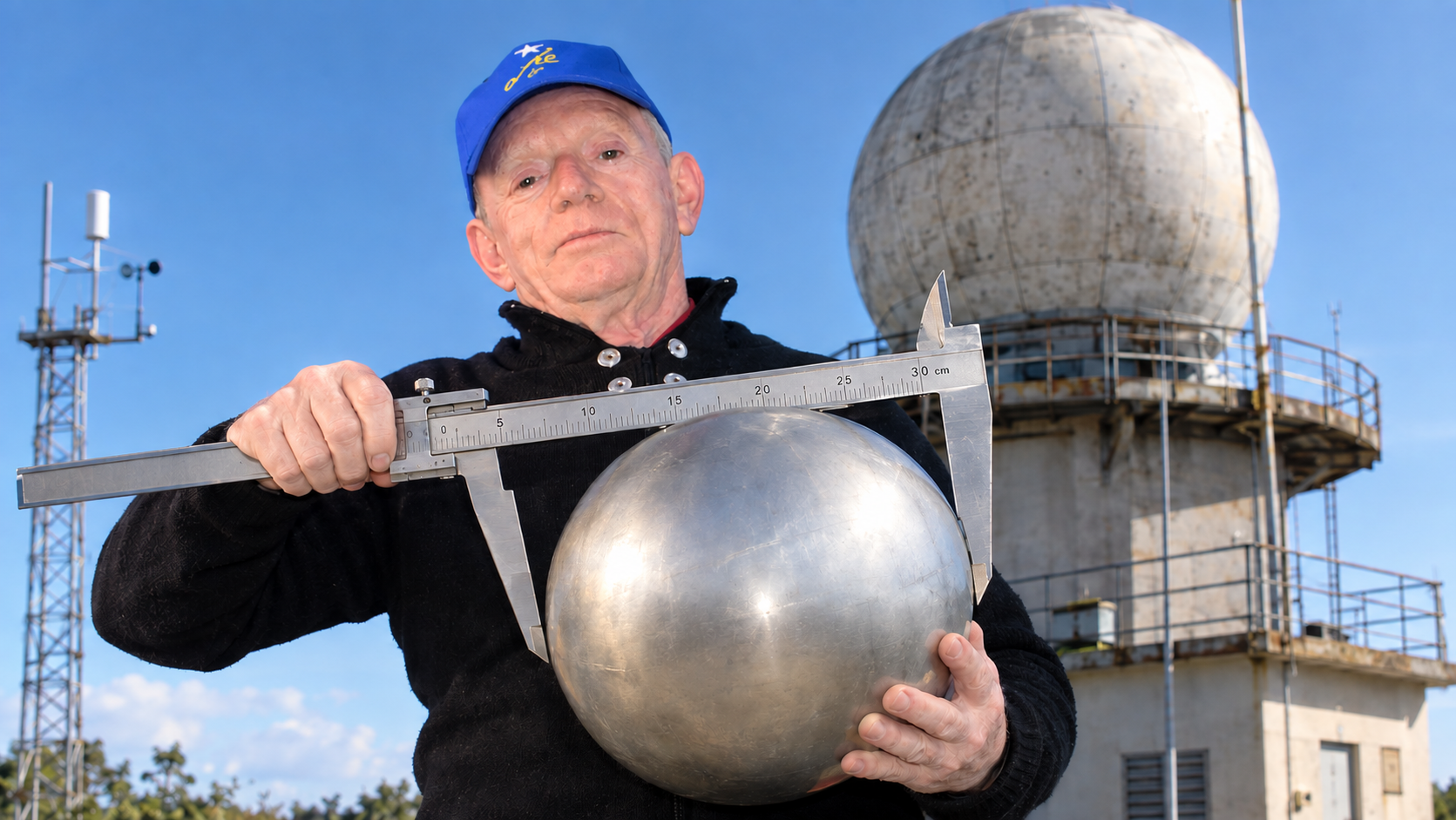
Discover why calibrating weather radars (WMO-No. 1257) is essential to move from qualitative images to real quantitative data in storm monitoring and precipitation estimation. Sharing uncalibrated radar data is like counting guavas and apples as if they were one and the same set. Versión en español aquí.
Introduction: the elephant in the room
In a regional network like the Caribbean’s, where radars from Cuba, the Dominican Republic, the Cayman Islands, Jamaica, Puerto Rico, Martinique, Guadeloupe, Curaçao, Barbados, Colombia, Guyana, or Trinidad and Tobago share a mosaic that feeds early warnings, there is a question rarely asked out loud: how similar are the data from one radar to another? And even more uncomfortable: how similar are they to the physical reality of the rain that is falling?
The answer, in most cases, is: we do not know, because the radars are not calibrated. This is not a minor technical failure. It means that, without calibration, a weather radar stops being a measuring instrument and becomes a generator of qualitative images: we see that something intensifies, moves, dissipates; but we cannot say how much rain has fallen, nor compare that “something” with what the nearby rain gauge measures, nor integrate it with data from a neighboring radar without introducing biases that invalidate any quantitative product.
This post is intended as a wake-up call for managers, decision-makers, and the WMO itself. The Guide to Good Practices for Operational Weather Radars (WMO-No. 1257), in its Volume V, devotes an entire volume to calibration, monitoring, and maintenance. It is not a luxury: it is the baseline without which everything else is decoration.
1. Three ways to use a radar, and only one serves for comparison
In the article “Weather Radars: Applications,” three modes of exploitation are clearly described, depending on the level of calibration maintained by the technical service:
Qualitative mode: the radar generates images that “adorn” publications. You can see evolution from weak to strong and dissipation, but without external reference. It cannot be compared with anything else. This is unfortunately the mode in which most radars operate, with a few exceptions.
Semi-quantitative mode: estimates of intensity and accumulations are obtained with an acceptable margin of error for certain applications (storm warnings, agriculture, aviation), but without the precision needed for rigorous hydrological or climatological studies.
Quantitative mode: precipitation accumulations are measured with errors comparable to those of a rain gauge network. This requires permanent calibration, correction against rain gauges, and complex processing.
Which applications require which mode?
Hydrological applications (1, 3, 6, 12, and 24-hour accumulations for flash floods, dams, and droughts): quantitative. They require local and seasonal Z-R relationships, correction for the bright band, hail, and beam blockage. Without calibration, accumulations are fiction.
Storm warning (detection of deep convection, mesocyclones, hail): semi-quantitative. The radar must rotate quickly (6 rpm or more) and scan the troposphere up to 16–20 km. Absolute precision matters less than early detection. But even here, without calibration, the reflectivity thresholds that trigger alarms are arbitrary.
Aeronautical applications (wind shear, microbursts, hail on approach): semi-quantitative to quantitative. The FAA requires resolutions of 365 m over the runway and beams passing below 62 m in height. An uncalibrated radar can underestimate a microburst or generate false alarms that paralyze an airport.
Agricultural and transport/port applications: semi-quantitative. It is enough to know whether it will rain and roughly how much, in order to decide on irrigation, grazing, or closing cargo holds.
Hurricane applications: here the radar provides valuable information even in qualitative mode (eye position, diameter, spiral bands). But to extract Doppler velocities, turbulence, or sliding accumulations, calibration is needed.
The conclusion is uncomfortable: if a regional network wants to produce data that can be compared between radars, assimilated into numerical models, or used for climatological verification, there is no shortcut: you have to calibrate.
2. What does it mean to calibrate a weather radar?
A weather radar is the most complex instrument in the meteorological arsenal. It measures distance, height, target dimensions, reflectivity, and with Doppler it adds radial velocity and spectral width. With polarimetry, differential reflectivity, differential phase, and correlation coefficient are added. Each of these variables has its own calibration.
Calibration, in the sense that matters here, is the comparison of a measured value with the correct value under specific conditions, documenting the deviation, calculating the uncertainty, and issuing the corresponding certificate. It is not “pointing at the sun and seeing the noise go up.” It is not “comparing by rule of thumb.” It is a scientific exercise with traceability, repeatability, and documentation.
The central problem is that the radar equation includes antenna parameters (gain, beamwidth) that are impossible to measure once the radar is installed at its operational site. The manufacturer provides values for a similar antenna, not yours, and even if they measured it at a test range, once it is mounted on your tower, with your radome and your environment, those values change. That is why you must always calibrate, just as you calibrate a voltmeter or a barometer.
3. Calibration methods: from helicopter to drone, from the sun to intercomparison
3.1. The metal sphere: the supreme method, and the most hated
In English-language literature it is incorrectly called “sphere calibration,” as if it were the sphere we were calibrating (in the cover image I poke fun at the name). It consists of suspending a conducting sphere of known diameter (for example, >30 cm for S-band) in the center of the radar beam, at a distance where there are no other targets. The sphere is in the geometric scattering region, its cross section is calculable, and the received power allows the radar constant to be solved. During my long 4-month internship in Nalchik, I was able to take part in a sphere calibration suspended from a helicopter, calibrating three radars of the hail-suppression service at the same time.
The problem is logistical: suspending the sphere from a helicopter, from hydrogen balloons, or from a kite. In Camagüey this was done for years: we tried helicopter, balloons, and kite, with successes and failures. The helicopter pilot complained that he could not stay still for long; the sphere was lost if the wind laid it down. But it is the only method that verifies all factors in the radar equation, including propagation factors.
Modernity has brought a cheaper and more repeatable solution: drones. A UAV equipped with RTK can hold a metal sphere in position with centimeter accuracy, without the noise of a helicopter and without the unpredictability of a balloon. The method has been adopted in research radars and is already being applied in operational networks. For a network like the Caribbean’s, where there are radars on islands with complex logistics, the drone is the most realistic way to calibrate against an absolute standard every few years.
3.2. The sun: daily, cheap, and automatable calibration
The sun emits in microwaves in a known way. By pointing the antenna at the solar disk and comparing the received power with the flux density measured by a solar observatory (such as Penticton, Canada, or data published by WMO), the receiver and antenna can be calibrated. It does not include the transmitter, but it is the second-best absolute calibration.
The advantage is that the sun is there almost every day. Solar calibration can be automated: the radar moves the antenna around the sun’s position, averages the measurements, and compares with the reference flux. At NCAR’s S-POL radar, the process I saw was completely automatic. In the European network, solar monitoring is routine to verify daily receiver stability and network homogeneity. My engineers tested the method on the Taiwan radar they installed.
3.3. Intercomparison between radars: when there is no absolute standard, the neighbor is the reference
If two radars are at a reasonable distance and there is a meteorological echo that fills the resolution volume of both, their reflectivities can be compared and the bias calculated. It is not an absolute calibration, but it is the only way to harmonize a network without taking a sphere to every site. In Cuba we practiced it assiduously, calibrating the Casa Blanca radar against Key West, then Casa Blanca with its neighbors, and so on eastward across Cuba.
Intercomparison requires strict conditions: the resolution volumes must be matched, the echo must be large enough to fill the beam, and many measurements must be made under different conditions to obtain acceptable statistics. WMO recommends intercomparison as part of continuous network monitoring, and the method has been used successfully between C-band radars and with the GPM/DPR satellite as a reference.
3.4. Other methods: corner reflectors, laboratory aircraft, fixed echoes
Corner reflectors mounted on tall towers: they provide a known and stable cross section. Rinehart describes them in his book. They are useful for routine verification, not for absolute calibration.
Laboratory aircraft with drop-size spectrometers: they allow the reflectivity calculated from the real spectrum to be compared with that measured by the radar. It is the most direct method for validating Z-R relationships, but it is expensive and infrequent.
Fixed reference echoes (TV towers, buildings): they serve to verify that the radar “is as it is every day,” but not to calibrate.
4. What WMO already says, and what managers should read
The WMO-No. 1257 Guide, Volume V, structures calibration into components: hardware calibration (transmitter, receiver, antenna pointing) and real-time adjustment and monitoring. It is not a theoretical document: it is an operational guide that says what to measure, how to measure it, and how often. Managers of radar networks should have it as a mandatory reference.
The case of Jamaica is illustrative. The country invested 7 million dollars in an S-band Doppler radar that became a pillar of its hurricane preparedness. The radar worked: it provided visibility into the evolution of Hurricane Melissa when previously they depended exclusively on the U.S. National Hurricane Center. But the question that does not appear in press releases is: is that radar calibrated so that its data can be compared with Barbados or Guyana in the Caribbean mosaic? If it is not, its value for WMO and for regional climate research is reduced to qualitative observation, which is much less than what was paid.
5. Conclusion: without calibration, there are no data; without comparable data, there is no network
An uncalibrated radar is not a measuring instrument. It is a camera that draws the evolution of something we cannot quantify, compare, or assimilate. For a regional network like the Caribbean’s, where radars must be integrated into a mosaic and feed cross-border warnings, calibration is not a technical detail: it is the condition of possibility for the data to have scientific and operational value.
WMO knows this, and has set it out in its guide. What is missing is for network managers and political decision-makers to make it a budgetary and operational priority. Calibrating is not an expense: it is what turns a radar into a sensor.
The debate remains open. How many radars in the region have a current, documented absolute calibration? How many could participate in an intercomparison without introducing unacceptable biases? The answers are probably uncomfortable; but they are the starting point for making the Caribbean radar network something more than a collection of pretty pictures.
If you like this topic, you may read the following related posts:
Deja una respuesta