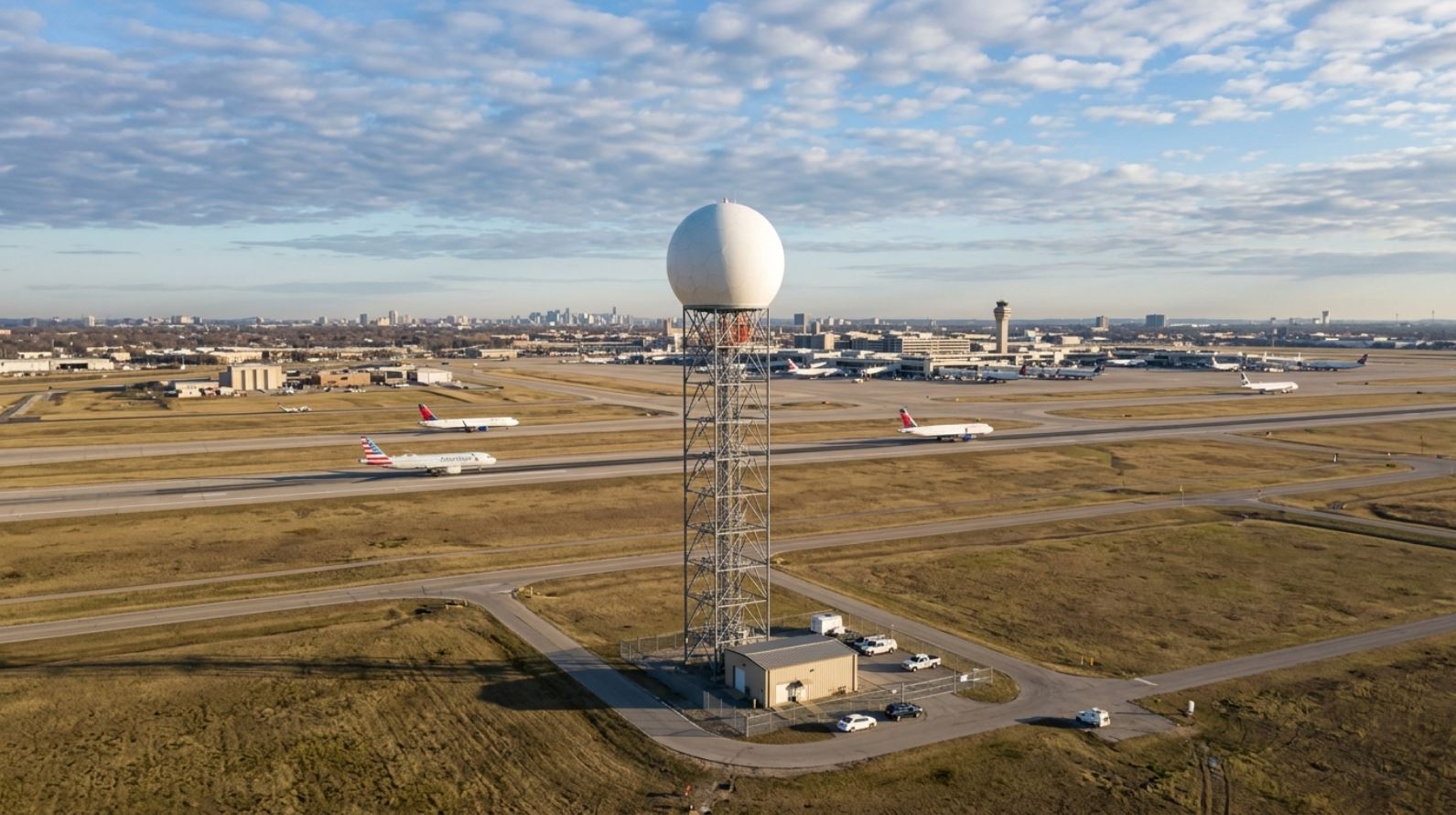
Post about optimal sitting of a weather radar to serve airport. Spanish version here.
I have been involved in the siting of several radars in my life. It all began with the MRL-5 radar, the first of its type to enter Cuba, with which we began our working life together. Although I was already a certified expert on MRL-5 radars, in 1986 the Casa Blanca one was installed, at the headquarters of the Institute of Meteorology itself; but I had no involvement in selecting the site. For a long time it was debated whether the Camagüey radar, which was at the Meteorological Center, should be raised by making a small hill right there or by constructing a small structure to elevate it; but it was not until 1997 that it was reinstalled in a fully automatic version (MRL-5M) at Loma de la Mula. In 2005 I took part in selecting the location and installation of the METEOR-1500S radar at Loma El Paraíso in Holguín. Seven years later, in 2012, we moved the Camagüey radar back to the Meteorological Center, turning it into the RD-200SX Radar, prototype of the Cuban Doppler Weather Radar. Finally, I was involved in installing the METEOR-735C radar in Las Nubes, Nicaragua. In none of the cases was an optimal installation with respect to an airport sought; decisions were made on purely logistical criteria. Nevertheless, over the years I collected everything related to selecting the site of a weather radar (especially Doppler radars) to provide services to an airport for detecting meteorological phenomena that generate adverse factors for air navigation. If my indulgent reader allows, I will share these criteria.
ICAO or WMO may have written suggestions on the location of a weather radar to serve an airport; but I have not found them. Everything I have been able to collect comes from the U.S. Federal Aviation Administration (FAA) and here I present it. Let us begin with some essential definitions.
Preliminary definitions
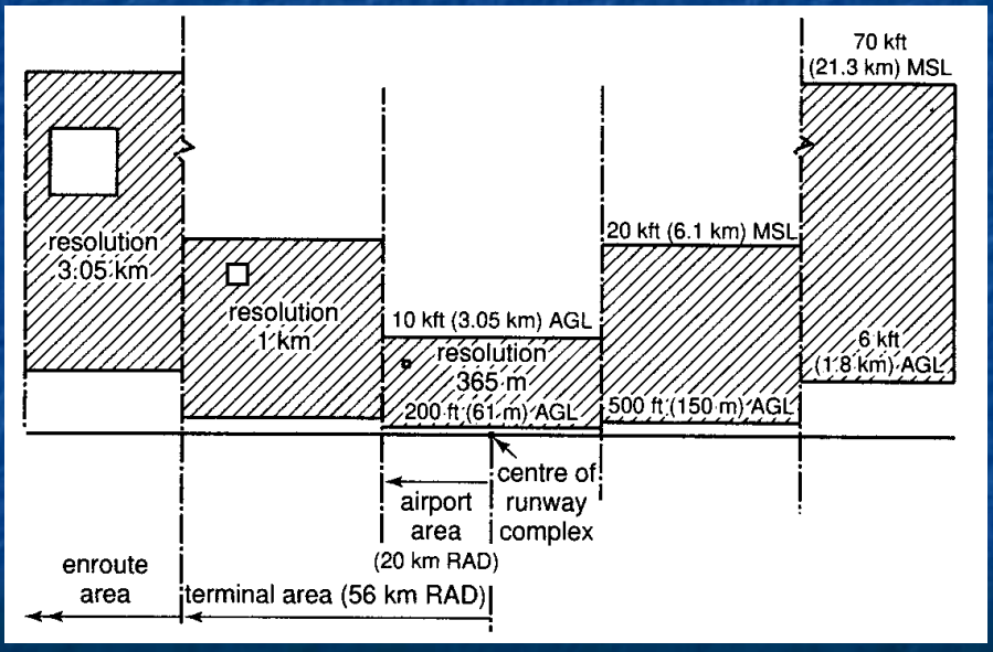
For the FAA, everything related to an airport is divided into three different spaces. The first is the aerodrome space, defined by a circle with a radius of 20 km, centered at the midpoint of the main runway and extending vertically from 200 feet above the runway (~60 m) to 10,000 feet (~3 km). The terminal space, defined as a circle with a radius of 56 km, centered at the midpoint of the main runway (that is, concentric with the aerodrome circle) and extending vertically from 500 feet above the runway (~150 m) up to 20,000 feet (~6 km). The rest of the airspace outside the terminal circle is called en route, and vertically it is considered from 6,000 feet (~1.8 km) up to 70,000 feet (~21 km).
Special coverage areas and regions
With respect to the possible detection of hazardous phenomena for aviation during takeoff and landing at an airport, the FAA establishes the following types of coverage that Doppler radars MUST guarantee to serve airports. Primary Coverage Region: a circle of 6 nautical miles centered at the midpoint of the main runway and vertically from a height of 600 feet (but very preferably from 300 feet) up to 19,700 feet. Microburst Alert Warning Area (MAWA) is a parallelepiped whose longest side is parallel to the runway’s longitudinal axis, covering the entire runway and extending 3 nautical miles beyond its beginning and end and having 1 nautical mile of width on its narrowest side, located symmetrically on both sides of the runway’s longitudinal axis. Gust Front Coverage Region is a circle of 31.8 nautical miles (but preferably 40 nautical miles, ~74 km) centered at the midpoint of the airport’s main runway.
Radar requirements
The FAA establishes that weather radars must guarantee Basic Coverage (for all types of hazardous phenomena) in a circle of no less than 48 nautical miles (~90 km) centered on the radar and vertically from the ground up to 70,000 feet (~21 km).
The FAA stipulates that weather radars must measure with a resolution no worse than: 1) 365 m in the aerodrome space; 2) 1 km in the terminal space; and 3) 3 km in the en route space. The resolution of a radar is given in the longitudinal direction of the radar beam by the transmitter pulse duration and in the direction transverse to the radar beam by the radar beam width. In modern digital radars, the resolution is modified by the acquisition system; but it will never be better than that of the radar itself as an instrument—do not let yourself be fooled by fallacies.
Doppler weather radars to serve an airport (specifically for wind shear detection) must have two peculiarities in Doppler mode: 1) One is that they must measure high velocities of weather phenomena without ambiguity; many Doppler radars offer the artifice of doubling (2X) or tripling (3X) the range of velocities to be measured. For aviation, these modes ARE NOT RECOMMENDABLE. Possibly klystron radars, which guarantee very low phase drift, can use 2X mode; magnetron radars should not use it for aviation. 2) They must have great sensitivity to detect phenomena that do not present high reflectivities.
Weather radars must guarantee that the special coverage areas and regions mentioned above do not fall either in the cone of silence (determined by the highest elevation angle at which the radar antenna scans) above the radar or in the dead zone (determined by the antenna switch delay).
It is not unimportant that the Doppler radar control system guarantee a scanning regime that can be updated at very short intervals (5–6 minutes for the complete scan; but the lowest angle should be updated more frequently). The automatic control and remote operation system (IoT) implemented in Cuban radars makes it possible to meet any requirement. Routinely, the eight Cuban radars update their information every 10 minutes ALL the time. Under special conditions they can switch to a more frequent scanning regime (every 5 minutes or less).
Weather radars must guarantee that the special coverage areas and regions mentioned above are not interfered with by fixed echoes that cannot be suppressed in processing. The FAA establishes that fixed echoes must obscure (hinder) less than 25% of the Microburst Alert Warning Area.
The radar must be located in a place where technical service can have 24/7/365 access. This requirement is not trivial. The monster Leonardo (Ichi) went to repair the METEOR-50DX weather radar (manufactured by SELEX), on the grounds of Pasto airport, Colombia, and to access the radar one had to cross over the runway; therefore, one had to wait until there was no aircraft traffic on it.
With respect to the microwave operating frequency (operating band), I will not go into much detail; I wrote a long article on the subject. Each wavelength has its advantages and disadvantages. Modern recommendations speak of placing an X-band radar (short-range) for the airport always under the global coverage of an S-band radar (in Cuba we have eight), and the data from both radars would have to be merged, so as to compensate for possible attenuation in the X band.
Of course, there are also a series of logistical considerations regarding power supply, electromagnetic interference, the absence of obstacles that block the radar beam in the direction of the runway, and others. In general, there are many requirements; it is difficult to meet them all with a single radar. In the United States it was thought that the NEXRAD radars would satisfy aviation’s needs, and that was not the case. To serve airports, under the same program, TDWR radars were manufactured for the 45 airports most in need.
My reader should keep in mind that radar manufacturers offer “seven versts to heaven,” as the Russians say; that is, they offer you wonder-radars—it is the phenomenon of post-truth applied to radar sales. All that glitters is not gold. If you are going to buy a radar for an airport (or for any other application), seek the advice of an expert; it will be money well spent, because there is a lot of quackery being offered out there.
Recommendations for optimal radar siting
Distance to the runway center. The radar should be located at an optimal distance of 10 nautical miles (18.5 km) from the runway center. The interval from 8 nmi (~15 km) to 12 nmi (~22 km) is permissible.
Aspect angle. The aspect angle is the angle formed by the runway’s longitudinal axis with the straight line joining the runway center to the radar position. The ideal angle is 0º (the radar should be on the longitudinal axis, at the beginning or end of the runway). This angle is preferably less than 20º, but up to 30º is allowed. The requirement is to guarantee that the Doppler radar, which only captures velocities along the antenna’s longitudinal axis, captures the greatest possible percentage of the wind shear value.
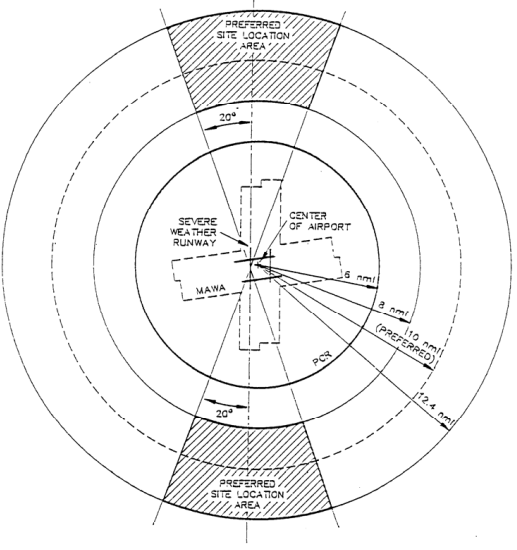
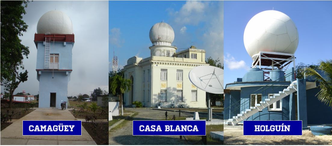
The above recommendations did not come out of nowhere; there are numerous articles and books explaining them in detail. In reality, in practice, these recommendations are unattainable. Weather radars may be located in the same aerodrome building, such as the old MRL-2 radar at Boyeros. They may be located very close to the runway, such as the RD-200SX Doppler radar (S and X bands) at Camagüey airport. They may also be located at a quasi-ideal distance, such as the RD-100S Doppler radar at Casa Blanca with respect to Boyeros (18.55 km, at an aspect angle of 33º) or the RD-100S-K Doppler radar in Holguín with respect to that city’s airport.
No real location is ideal; in all cases another radar would be needed to COMPLEMENT the coverage of the radar intended for the airport and to be able to detect with certainty any hazardous phenomenon. If the reader wishes to dive into these topics, I recommend the article “Optimum siting of NEXRAD to Detect Hazardous Weather at the Airport,” by P. R. Mahapatra, D. S. Zrnic, and R. L. Doviak, published in Volume 20, Number 4, 1982, of the Journal of Aircraft.
At some point I began a study of how well the eight radars operated by the Institute of Meteorology and the three nearest foreign ones—Key West, Grand Cayman, and Guantánamo Naval Base—provide coverage to Cuban airports; but I believe I did not finish it; after all, nobody was interested in that. It really is a pity that aviation does not take full advantage of what Cuban radars can offer.
Since 2009, the eight Cuban radars scan the troposphere every 10 minutes (they can do so more frequently), and the data obtained is processed with NEXRAD-ORPG, the same software used by the 159 WSR-88DP radars of the United States weather service, and it is ready in a matter of seconds for the entire world. Especially the three Doppler radars manufactured on the instructions of the Commander in Chief provide many useful products for meteorological service to air navigation; everything is ready, it is just a matter of reaching an agreement, and this is very easy in a socialist country with a state-centralized economy… I say; don’t take my word for it, draw your own conclusions.
You can consult the following articles if the subject of aviation is of interest to you:
Deja una respuesta